Monday, December 16, 2013

New Data Portal Feature: Clustered Points for Multi-Site Locations

Think about your last visit to your doctor. Did you go to a medical office building or to a standalone practice?

The United Way of Greater Cincinnati shares the same address as the Visiting Nurses Association, Local Initiatives Support Corporation (LISC), and several affiliated United Way agencies.

So what, you're saying. Who cares?

Well, if you're mapping data, you should.

You see, some GIS data viz tools get confused when multiple agencies share the same physical address. They can only display one point on the map, so they pick one, usually the one "on top," the one the underlying code accesses first.

This isn't good.

Why? Because when you click on the point, you see data for only one agency, not every agency at that address. You get results for one clinic, not for every clinic in the building. The results can be incomplete at best, misleading at worst.

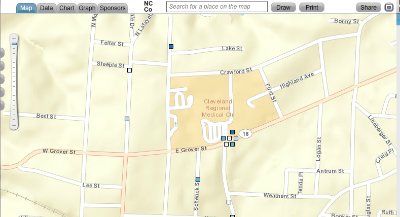
A screen shot showing one point that represents multiple sites.
The point could represent multiple clinics, physician practices, or social service agencies that all share the same address.


That's why we've added a new feature called clustered points to our Community Data Portal. It's a behind-the-scenes feature, one you don't have to access or configure in any way.

When you click on a point that has multiple sites, the points spread out. Each point becomes clickable, and each site's unique data becomes visible. You see all data relevant to that location, not just a portion of it.


Map showing clustered points. When you click on a point that represents multiple sites,
the points spread out, showing data for every site at that location.


The Community Data Portal is but one way to map population data. Register today for one of our free HealthLandscape webinars to learn more about GIS data visualization.


Visualizing Data with HealthLandscape
Overview of all of our data visualization tools, including the Site Performance Explorer
Tuesday, December 17, 2:00 pm ET
Introduction to HealthLandscape
In-depth instruction on using HealthLandscape, our free online mapping tool and data library
Tuesday, January 7, 2:00 pm ET
The Community Data Portal
In-depth demonstration of our award-winning data dissemination tool
Tuesday, January 14, 2:00 pm ET

Monday, December 9, 2013

Congratulations to Michael Topmiller, PhD!

Michael Topmiller, PhD
Congratulations to Michael Topmiller on his recently awarded PhD from the University of Cincinnati Department of Geography. You've met Michael (virtually) if you've sat in on any of our webinars. He's the voice behind the slides, the person who so capably demonstrates our tools and answers your questions. When he's not presenting webinars, he's wrangling data sets and configuring mapping tools.

For his PhD, Michael focused on the Licking River Greenway and Trails (LRGT) in Covington and asked, "How does including local perceptions of safety change how we view access to physical activity resources, especially among low-income and minority populations?"

The LRGT extends along the Licking River in Northern Kentucky, and winds through several Covington neighborhoods, including Eastside, Helentown, Austinburg, Wallace Woods, and Levassor Park. Many residents there, particularly in Eastside, Helentown, and Austinburg, live in poverty.

Study area along the Licking River Greenway and Trails.
The map on the right shows the percentage of the population in poverty.


Sidewalk Audits and Participatory Mapping Show Neighborhood Conditions


Michael enlisted Covington residents, as well as adults from the Center for Great Neighborhoods and adolescents taking part in a week-long summer digital photography class called "Youth Picture Covington" to document access points and sidewalk quality. He also asked them to share their perception of safety along the greenways, recognizing that even the best sidewalks won't be used if residents are concerned about safety.

They assessed a number of features of the built environment, including:
  • Sidewalk presence: complete or incomplete
  • Sidewalk condition: good, fair, or poor
  • Traffic: no traffic, some traffic, heavy traffic
  • Safety: safe, neutral, not safe


Neighborhood Data Mapped for Better Analysis


Michael then took participants' data and used GIS to analyze the results. He visualized both adult and adolescent data.

Mapped data showing locations of complete sidewalks.

Mapped data showing sidewalk conditions in study area.

Mapped data of local residents' perceptions of traffic volume in study area.


Mapped data of local residents' perceptions of safety in study area.


Findings analyzed and mapped against poverty levels.


Lessons Learned


Michael's research identified many positives:
  • Good proximity of access points to neighborhoods and schools
  • Good presence and quality of surrounding sidewalks
There were also some areas of concern:
  • High perception of poor safety and high traffic near schools and access points
  • Barriers to access are more prominent in under-resourced neighborhoods
Targeted interventions and policy changes should consider not only the built environment, but also local perceptions of safety and traffic volume.

Michael will be presenting several upcoming HealthLandscape webinars. He'll also be glad to answer questions about his research during the webinars.

Register today to see how GIS visualization can help you see your neighborhoods in a new light.


The Community Data Portal
In-depth demonstration of our award-winning data dissemination tool
Tuesday, December 10, 2:00 pm EST
Visualizing Data with HealthLandscape
Overview of all of our data visualization tools, including the Site Performance Explorer
Tuesday, December 17, 2:00 pm ET
Introduction to HealthLandscape
In-depth instruction on using HealthLandscape, our free online mapping tool and data library
Tuesday, January 7, 2:00 pm ET

Wednesday, November 20, 2013

GIS Data Visualization: Indispensable for Policymakers and Community Leaders

The Data! Fostering Health Innovation in Kentucky and Ohio conference proved to be a showcase for GIS technology in practice.
The Data! Fostering Health Innovation in Kentucky and Ohio conference
proved to be a showcase for GIS technology in practice.
Geospatial data visualization is an indispensable tool for policymakers and community leaders, as evidenced by yesterday's Data! Fostering Health Innovation in Kentucky and Ohio conference. Although the conference was not intended to be a showcase for geospatial information system (GIS) technology, almost every presenter used geospatial data visualization and analysis to tell their story. In many cases, it was the story.

Here are three highlights from the day.


GE Aviation Uses GIS Data Visualization to Improve Employee Health


GE Aviation is using a customized version of HealthLandscape's Site Performance Explorer to bring common sense and creativity to its efforts to improve employee health. For example, GE used to spread a "Stop Smoking" message only among its workers. Now the company uses GIS data visualization to see the prevalence of smoking in the communities that surround its sites. When a visualization shows high smoking rates, GE extends its nonsmoking promotions throughout the community because the company recognizes that employees are more likely to stop smoking if their friends and family members don't smoke. GE uses their customized app to address other health issues as well, such as improving employee access to primary care providers and promoting health screenings.

Why GIS? Because GIS data visualization draws attention to factors within a community that can directly affect an organization.

The City of Louisville Tackles Asthma Using GIS Data Visualization


Ted Smith, Chief of Economic Growth and Innovation for the city of Louisville, Kentucky, is using GIS data visualization not only to improve residents' health, but also to increase the region's economic vitality.

Statistics show that Louisville has extremely poor air quality--among the worst in the nation--making it a challenging place for people with asthma to live. High asthma-related emergency room admission rates and poor air quality scores make it difficult to attract and retain businesses. Smith has initiated a program with Propeller Health to supply Louisville-area residents with GIS-equipped inhalers. Each time a patient uses their inhaler, sensors record when and where the puff was taken. Analysts then combine inhaler data with weather, air pollution, traffic pattern, and other large data sets to look for ways to intervene, on both the patient and the policy level.

There have already been some surprising findings. For example, residents generally avoid living on the city's west side, where large industrial complexes are located and pollution levels are perceived to be high. Data have shown, however, that particulate matter levels are much higher in Louisville's wealthiest neighborhoods, likely due to weather patterns and the city's topographical characteristics. GIS data visualization shows just how pronounced the difference is.

Why GIS? Because GIS data visualization can show truths that run counter to our intuition.

Ohio-Kentucky-Indiana Regional Councils of Government Uses Crowdsourcing to Map Bike Routes 


Ohio-Kentucky-Indiana Regional Councils of Government (OKI) wanted to create bike route maps for Northern Kentucky and Ohio. They tried traditional outreach methods (e.g., email, meetings) to engage the cycling community. Their most successful effort was a survey conducted at local bike shops. They received a total of 34 responses.

OKI decided to try a new approach: crowdsourcing. They created a simple online mapping platform and invited the cycling community to add bike routes to the online map. They also invited riders to share their experiences with those routes. The resulting Bike Route Guide is now a permanent part of OKI's website (click here for the link).

Why GIS? Because GIS data visualization can invite participation and community engagement in a way that traditional methods do not.

At HealthLandscape, we strive to create GIS data visualization tools that don't require GIS specialists to use them. We want you to be able to make your data accessible, "mash it up" with other data sets, and use the visualizations to ask questions and formulate solutions to your community's challenges.

To learn more about our GIS data visualizations, attend one of our free webinars.

Introduction to HealthLandscape
In-depth instruction on using HealthLandscape, our free online mapping tool and data library
Thursday, December 5, 2:00 pm ET
The Community Data Portal
In-depth demonstration of our award-winning data dissemination tool
Tuesday, December 10, 2:00 pm EST
Visualizing Data with HealthLandscape
Overview of all of our data visualization tools, including the Site Performance Explorer
Tuesday, December 17, 2:00 pm ET

Thursday, October 31, 2013

Agenda Announced for Data! Fostering Health Innovation in Kentucky and Ohio Conference


Data! Fostering Health Innovation in Kentucky and Ohio

Tuesday, November 19, 2013, 9:30 am to 4:00 pm ET

Northern Kentucky University METS Center

FREE


Have you registered yet? You can still get in, but we need your reservation by November 9.

The Data! Fostering Health Innovation in Kentucky and Ohio conference will showcase novel and effective uses of health data in the Kentucky-Ohio region. We'll welcome keynote speakers Dwayne Spradlin (CEO of the Health Data Consortium) and Damon Davis (Director of the Health Data Initiative of the U.S. Department of Health and Human Services).

The conference is organized around Thomas R. Frieden's Health Impact Pyramid. The Health Impact Pyramid is a framework that describes different types of public health interventions. Interventions at the base of the pyramid (socioeconomic factors) have potential to impact the greatest number of people; interventions at the top of the framework (counseling and education) require more work on an individual level. (Click here to read a great blog post by Jennifer Chubinski, Director of Community Research at Interact for Health, which presents readers' suggestions on how to apply the pyramid.)

Panel sessions will address three of the five tiers of the Health Impact Pyramid.

Socioeconomic Factors Panel: moderated by Ross Meyer, Vice President, Community Impact, United Way of Greater Cincinnati
  • Simplifying Data to Drive Health and Productivity Strategies: Craig Osterhues, Manager, Health Services, GE Aviation
  • UDS Mapper: Jennifer Rankin, Geospatial Informatics Senior Analyst, Robert Graham Center
  • Exploring the Facts Matter Data Portal: Eric Rademacher, Co-Director, Institute for Policy Research, University of Cincinnati
Changing the Context Panel: moderated by Gabriela Alcalde, Health Policy Director, The Foundation for a Healthy Kentucky
  • Mapping Louisville's Urban Trees: Collecting Baseline Data for a Healthier Community: Pat Smith, Community Planner and Evaluation Researcher with REACH Evaluation and Director, City Collaborative
  • Food Deserts in Hamilton County: Chris Auffrey, Associate Professor, School of Planning, University of Cincinnati
  • Exploring Access to Walking and Biking Trails Using Sidewalk Audits and Participatory Mapping: Michael Topmiller, Doctoral Candidate, Department of Geography, University of Cincinnati and GIS Data Specialist, HealthLandscape, LLC
  • The Cincinnati Bike Flash Map Campaign: Using a Crowd Source Strategy to Map Bike Routes in Cincinnati: Gayle Foster, Project Administrator, Ohio-Kentucky-Indiana Regional Council of Governments
Long-Lasting Protective and Clinical Interventions: moderated by Karen Bankston, Associate Dean of Clinical Practice, Partnership, and Community Engagement, University of Cincinnati College of Nursing
  • Louisville Asthmapolis Project, Civic Health Data: Citizen as Sensors: Ted Smith, Chief of Economic Growth and Innovation, Louisville Metro Government
  • M2M Online Delivery: Healthcare's Next Megatrend: Chuck Thornbury, Founder, meVisit Technologies
  • Overview of the Health Benefit Exchange, KyNect: Carrie Banahan, Executive Director, and Bill Nold, Deputy Executive Director, Kentucky Office of the Health Benefit Exchange
And we'll announce the winner of our infographic competition!

We invite your participation on November 19. Lunch is provided, and you'll have an opportunity for roundtable discussions with the panelists.

Only a few spots remain, so register today!


Please note: The conference is co-sponsored by HealthLandscape, Interact for Health, and the Foundation for a Healthy Kentucky. Registration is free, but we must assess a $75 cancellation charge for any guest who cancels after November 9.

Monday, October 28, 2013

When Do I Use QuickThemes? When Do I Use QuickGeocodes?


Have you ever tried plugging your own data into HealthLandscape and not gotten the results you expected? This happened to one of our users recently. After a quick phone call, we realized we needed to offer some clarification on using QuickThemes and QuickGeocodes.

QuickThemes and QuickGeocodes are two of HealthLandscape's most powerful and popular tools. Both tools:
  • Enable you to upload your own data and create your own maps.
  • Require no GIS expertise to use them.
  • Are free for small data sets. Simply log in to www.HealthLandscape.org to get started and select either QuickThemes or QuickGeocodes from the Tools menu.
There is one major difference between the two tools:
  • QuickThemes requires aggregate data.
  • QuickGeocodes requires address (a.k.a. point-level) data.
This is important, because if you upload the wrong kind of data into the tool, the tool will not work.

Aggregate data "rolls up" individual pieces of data into one collection--a summary, if you will. You see information that applies to a geographical area (sometimes called a geography) rather than to individuals within the geography. It's impossible to garner person- or site-specific information from aggregate data.

Address data (a.k.a. point-level data) is very specific. In GIS terms, it can be displayed as a single point on a map. The point could represent the address of a school, the address of a farmer's market, or even the address of a specific person. Because of that specific address, anyone who views the map can figure out a lot about that person or site. You have to be careful about how you use point-level data. You don't want to inadvertently invade someone's privacy or misuse their data.

Here's a scenario that might further clarify the difference. Perhaps you work for a community health agency that provides on-site clinic care, but also offers in-home support to selected patients. You have a spreadsheet that contains the addresses for every patient you have served over the past year. When would it make sense to use QuickThemes, and when would it be better to use QuickGeocodes?

You might use QuickThemes when you want to see which Zip codes or counties most of your clients come from, or if you're trying to figure out where to locate a new clinic site. Take the spreadsheet, total the number of patients from each county, and map those totals against the corresponding county. You could also tally other demographic information, such as race, insurance status, employment status, or other data variables you collect.

The map might look something like this:

QuickThemes maps aggregate data
Map created using HealthLandscape's QuickThemes tool.
QuickThemes creates maps of aggregate data.
You might use QuickGeocodes when you are trying to understand where patients with asthma or diabetes are located. You could display those addresses on a map, and send a diabetes educator to visit homes of patients' whose glucose levels exceed a certain threshold.
The map might look something like this:

QuickGeocodes maps point-level data
Map created using HealthLandscape's QuickGeocodes tool.
QuickGeocodes creates maps of point-level data.


Twice a month, we offer free "Introduction to HealthLandscape" webinars to help you use HealthLandscape effectively in your context. All of our webinars are live, so they are perfect opportunities to get clarification and ask questions.

Register today!


Introduction to HealthLandscape
In-depth instruction on using HealthLandscape, our free online mapping tool and data library
Tuesday, October 29, 2:00 pm ET
The Community Data Portal
In-depth demonstration of our award-winning data dissemination tool
Thursday, November 7, 2:00 pm EST
Visualizing Data with HealthLandscape
Overview of all of our data visualization tools, including the Site Performance Explorer
Wednesday, November 20, 2:00 pm ET


Monday, October 14, 2013

New GIS Visualization: The Inpatient Hospital Costs Explorer

Today we are at the Esri Health Conference in Cambridge, Mass., presenting the Inpatient (IP) Hospital Costs Explorer. The IP Hospital Costs Explorer, one of our newest visualizations, lets users compare US hospitals on two measures:
  • Price
  • Quality
The IP Hospital Costs Explorer combines two data sets: Medicare Provider Charge Data (Inpatient), which was just released in May, and Hospital Compare Patient Survey Data (from Medicare.gov). Patients, their families and caregivers, and clinicians can use the Explorer to make an informed decision about which hospital may provide the best care experience.

Users begin by choosing a geographic area. (The version shown has selected indicators for Ohio, Kentucky, and Indiana.) A green circle indicates hospitals with low costs, yellow indicates hospitals with moderate costs, and red indicates hospitals with high costs.

The Inpatient (IP) Hospital Costs Explorer showing hospitals with low (green),
medium (yellow), and high (red) costs for the top 100 Medicare diagnosis-related groups.

When users click one of the circles, flyout menus appear that give more detail about the cost of specific covered charges. (The data set includes selected indicators from the 100 most common Medicare DRGs.) There is also a flyout menu that shows patient satisfaction survey results. This is particularly helpful when costs are similar between two hospitals.

Flyout menus give additional detail about hospital costs and patient satisfaction survey results for each hospital.
The IP Hospital Costs Explorer also includes the Medicare Data Portal, which presents data from the Centers for Medicaid and Medicare (CMS) Geographic Variation database and the Chronic Conditions warehouse at the hospital referral region (HRR) level. Users can visualize the data through maps, graphs, and charts, and can also examine the relationship between two indicators using comparison tools.

The Medicare Data Portal, showing the prevalence of Alzheimer's Disease by hospital referral region.
The Columbus, Ohio, hospital referral region is highlighted.


Learn more about the IP Hospital Costs Explorer and other HealthLandscape GIS visualizations by attending one of our free live webinars:

Visualizing Data with HealthLandscape
Overview of all of our data visualization tools, including the Site Performance Explorer
Tuesday, October 22, 2:00 pm ET
Introduction to HealthLandscape
In-depth instruction on using HealthLandscape, our free online mapping tool and data library
Tuesday, October 29, 2:00 pm ET
The Community Data Portal
In-depth demonstration of our award-winning data dissemination tool
Thursday, November 7, 2:00 pm EST

Thursday, October 3, 2013

Three Reasons Interactive GIS Data Visualizations Get Your Message Across Faster

Last week, we were among the featured innovators at an event that brought together emerging life science companies, prospective investors, policymakers, and other people who want to significantly improve health in the Greater Cincinnati region.

We set up in a beautifully appointed conference room and began rolling a video that highlighted several of the HealthLandscape tools on a giant LED monitor. Our presentation commanded the audience's attention.

Why? What was so compelling about these interactive maps?

We noticed that almost every person who stepped into the room engaged with what they were seeing in the same three ways:

They immediately had a frame of reference.

What did they look for first? Their neighborhood. Their community. Their landmarks. They quickly found where they belonged, and shifted their focus to the data we were presenting. We didn't have to spend time setting up the context. They already had it.

They immediately began looking for patterns.

People began asking questions and making observations: Why are so many clustered in that area? What does that shading represent? That's not what I would have expected there. I'm surprised that number isn't higher. People quickly began trying to make sense of the complex data. Seeing the data geographically energized and engaged them.

They immediately wanted to take the data further.
Once the initial observations were made, the audience wanted to dig deeper. They wanted to find meaning in the data. They wanted to not just observe a pattern but also understand why the pattern might be occurring. Is there a high level of unemployment in that area? What about poverty? Does that cluster of people with severe heart disease have access to a hospital? Because of HealthLandscape's interactive design and full library of community data, their questions could be addressed as their mental wheels were turning, while they were beginning to imagine ways to meet the identified need.
Our minds process visual information more quickly than textual information. One writer demonstrates this by placing a drawing of a circle next to a paragraph of text that gives a definition of a circle. Which do you have to work harder to understand: the image or the definition? And which will you remember?


Which do you understand more quickly--the map or the table? Both show the same data.


While any visualization has the potential to be "sticky," GIS visualizations go one step further because viewers have the potential to make a personal connection with the data. Your audience, whether it is a community of care providers, policymakers, funders, or the very people you serve, look for where they are in relation to the data, and ask, "How does this affect me?"

To learn more about HealthLandscape's interactive GIS data visualizations, attend one of our regularly scheduled webinars:

The Community Data Portal
In-depth demonstrations of our award-winning data dissemination tool
Thursday, October 3, 2:00 pm ET
Introduction to HealthLandscape
In-depth instruction on using HealthLandscape, our free online mapping tool and data library
Tuesday, October 8, 2:00 pm ET
Visualizing Data with HealthLandscape
Overview of all of our data visualization tools, including the Site Performance Explorer
Tuesday, October 22, 2:00 pm ET

Wednesday, September 18, 2013

Data Visualization: Luxury or Necessity for Managing Population Health?

This is National Health IT Week. We're participating in the National Health IT Week Blog Carnival, offering our perspective on "The Value of Health IT" to improve healthcare delivery. Click here to see other National Health IT Week blog posts. Read contributions from Cincinnati-based health IT companies at Innov8 for Health.

Health IT is transforming healthcare delivery. Electronic medical records are in use in almost every hospital system and physician practice. Apps that help patients track glucose levels, medications, sleep cycles, and more are being introduced and improved daily. These are terrific innovations at the patient level. But how is Health IT being applied to population health?

One answer: data visualization.

Visualization tools--no matter the industry--make it easier to see relationships and identify patterns among data sets. In the field of population heath, where the twin goals of managing cost and providing quality healthcare often seem to be at odds, data visualization tools offer users a way of aggregating, displaying, and making sense of information, especially information that comes from disparate sources.

At one time, we used visuals to make our point, tell our story, and--let's be honest--keep our audience engaged and awake during presentations. We thought that was enough, and that anything "beyond the basics" was overkill--a waste of both time and money.

We can no longer afford to be so complacent. Today's visualization tools have evolved from pretty picture generators to genuine decision-making tools. Most data visualization tools can give you:
  • Real-time data analysis
  • Trend analysis
  • Dashboards that alert you to values that fall outside of established benchmarks
  • The ability to visualize multiple data sets from multiple sources
  • Interactivity
  • Access to data for non-data specialists
HealthLandscape specializes in online mapping tools, which give users the ability to see geographic variations among the populations they serve. This is especially critical in today's health care environment, where providers are increasingly held responsible not only for the health of their patients, but also for the health of their communities.

Health promotion efforts focus on reaching populations at-risk for chronic conditions such as diabetes, respiratory diseases, and heart conditions before these conditions manifest. Health management plans now incorporate community-based care as a way of decreasing costs and improving clinical outcomes.

Bottom line: It's impossible to manage the health of a community without knowing that community.

To learn more about HealthLandscape's data visualizations, attend one of our regularly scheduled webinars:

The Community Data Portal
In-depth demonstrations of our award-winning data dissemination tool
Thursday, September 19, 3:00 pm ET
Visualizing Data with HealthLandscape
Overview of all of our data visualization tools, including the Site Performance Explorer
Tuesday, September 24, 2:00 pm ET
Introduction to HealthLandscape
In-depth instruction on using HealthLandscape, our free online mapping tool and data library
Thursday, September 26, 2:00 pm

Tuesday, September 10, 2013

How Are You Measuring Health Promotion in Your Region?

How do you measure health promotion activities in your region? What performance indicators show that your health promotion efforts are producing results?

We're curious because one of our partner organizations, The Health Foundation of Greater Cincinnati,* has shifted its strategic direction away from access to care and toward health promotion. Now called Interact for Health, the organization's primary focus is on:
  • Healthy eating
  • Active living
  • Mental and emotional well-being
  • Healthy choices about substance use
Interact for Health has organized its new strategy around the National Prevention Council's National Prevention Strategy. In Appendix 2, the document lists categories of key indicators, including:
  • Goal indicators
  • Leading causes of death
  • Healthy and safe community environments
  • Clinical and community preventive services
  • Empowered people
  • Elimination of health disparities
  • Tobacco-free living
  • Preventing drug abuse and excessive alcohol use
  • Healthy eating
  • Active living
  • Injury and violence-free living
  • Reproductive and sexual health
  • Mental and emotional well-being
Many of the data sets that match the key indicators listed in the National Prevention Strategy are included in HealthLandscape's Community HealthView tool, which is easily accessible, free, and ready to use. To learn how to access data in Community HealthView, click the link below to sign up for an Introduction to HealthLandscape webinar.
How are you measuring health promotion? What's working for you?

*HealthLandscape, LLC is a partnership of Interact for Health and the American Academy of Family Physicians' Robert Graham Center.

Monday, September 9, 2013

You're Invited: Data! Fostering Health Innovation in Kentucky and Ohio


Data! Fostering Health Innovation in Kentucky and Ohio

Tuesday, November 19, 2013, 9:30 am to 4:00 pm ET

Northern Kentucky University METS Center

FREE


Mark your calendars for this free, day-long event!

HealthLandscape is proud to co-sponsor the upcoming Data! Fostering Health Innovation in Kentucky and Ohio conference. Join us for a day of fast-moving presentations that will showcase novel and effective uses of health data in the Kentucky–Ohio region.
Damon Davis
Director, Health Data Initiative
U.S. Department of
Health and Human Services
Dwayne Spradlin
CEO, Health Data Consortium

Keynote speakers Dwayne Spradlin and Damon Davis will give national and federal context for health innovation. Other presenters will address:
  • Contextual data for community benefit planning and local asset mapping
  • Built environment strategies to help make the healthy choice the easy choice
  • Novel approaches to chronic disease management and increased access to care
Lunch is provided, and will offer an opportunity for topical roundtable discussion.

Space is limited to the first 250 who register, so register today!

We look forward to seeing you on November 19!

Please note: The conference is co-sponsored by HealthLandscape, Interact for Health, and the Foundation for a Healthy Kentucky. Registration is free, but we must assess a $75 cancellation charge for any guests who cancel after November 9.

Wednesday, August 21, 2013

7 Ways Data Sharing Can Make Your Organization Stronger


Sharing data with your community
can provide tangible benefits for your organization.

Photo ©iStockphoto.com/Peter Booth and Alexandra Booth

We hear a lot about data these days: big data, open data, proprietary data, market data, metadata.

But we don't hear a lot about data sharing. At least not in business or nonprofit circles.

Data sharing is fairly common among university and research institutions who see their data as a public asset. Federal, state, and local governments have begun to step up and release useful data sets. But beyond institutional walls, there is still widespread reticence against letting anyone outside the organization have access to "our" data.

So why would you, as a private company or nonprofit, want to share your data?


1. It makes your data more valuable. 


Your data is just that: your data. By adding your data to others', a fuller picture emerges of what is really happening in your market, industry, or community. This is true whether you formally "pool" your data into a data portal, or simply compare your data against other data sets.


2. It promotes collaboration.


Data sharing helps you choose partners wisely. You're a business owner, and until you sought out that specific data set, you did not realize that Company X had the potential to be an excellent strategic partner. You're a nonprofit executive director just beginning to realize the power of collective impact. By opening up your data, you can more easily answer the question, "Who else is working in this field?"


3. It promotes innovation.


Building 20 at MIT became well-known as an incubator for innovation. Educators and researchers from disparate fields occupied the space, and in the natural course of their workday, they bumped into each other. Through conversations and generally taking an interest in one another, new ideas sprang forth, ideas which may not have come about otherwise.

The same can occur when you share your data. You may inadvertently generate a new app, a new insight, or a new way of looking at the world because you generously made your data available to all.


4. It demonstrates your organization's transparency. 


Every organization has a level of accountability. Businesses must be accountable to their shareholders and consumers; nonprofits must be accountable to their donors and constituents. All must be accountable to their community.

By willingly sharing your data with the community at large, you demonstrate that you are willing to be accountable for your organization's strengths, you are willing to accept responsibility for areas that need improvement, and you are open to being vulnerable to both praise and criticism. All of these actions help to build trust.


5. It enlarges your worldview. 


When you're the only one looking at your data, you can only see things from your point of view. By exposing your data to the rest of the world, you invite comment--and insight. Viewers outside your organization bring their own experience to your data, and may be able to give you a new perspective that might never have been realized had the data been kept internal.


6. It's a two-way street.


Data sharing begets data sharing.Your courage in stepping out will invite others to do the same.


7. It makes things happen.


Data sharing doesn't have to be passive. Host a hackathon to build that elusive app you've been putting off for months. Sponsor a data visualization contest around your data. Tell the data viz team the concept you're trying to express, and let them have a go at it. Design an event that matches creativity to a legitimate need and see what emerges. If nothing else, you've built goodwill and had fun in the process.

We're not suggesting that you release all of your data. Or confidential data. Just data that could benefit the community as a whole. And of course you must employ some safeguards. In a future post, we'll give you some guidelines on how to cleanse and de-identify your data, so that you can share your data with confidence.

Have a specific question about making your data accessible? Contact us at info@healthlandscape.org.

Or visit www.HealthLandscape.org to sign up for a Community Data Portal webinar. (Next one is tomorrow, August 22 at 3:00 pm ET. Click here to register.)

Thursday, August 15, 2013

New Study: Greater Cincinnati's Ability to Meet Demand for Primary Care Physicians

Greater Cincinnati's current and projected (2017)
need for
primary care physicians
A new study has found that Greater Cincinnati does not have enough primary care physicians to meet current demand, and that this deficit could increase in the next five years as the Affordable Care Act is fully implemented.

The study was commissioned by the Executive Stakeholders' Council and was published by the Health Collaborative. Jené Grandmont, Health Informatics Specialist at HealthLandscape, is the study's coauthor.


Goals


The study covered the following nine counties: Adams, Brown, Butler, Clermont, Hamilton, and Warren counties in Ohio, and Boone, Campbell, and Kenton counties in Kentucky. Its goals were threefold:
  • To determine the number of primary care physicians practicing in the nine counties named above
  • To evaluate the potential need for primary care physicians currently and in five years
  • To make recommendations for the region to meet any needs that were identified


Findings


The study conservatively estimates that Greater Cincinnati needs 200 more primary care physicians to meet current demand and, unless the need is addressed, will require 250 by 2017. The study defined primary care physicians as "family medicine physicians, internal medicine physicians and general practice physicians (who have no specialty training beyond internship) serving the adult population."

The study also noted:
  • Physician deficits vary by county.
  • The number of Medicaid recipients will increase by 25 percent throughout the study area if both Ohio and Kentucky expand Medicaid coverage.
  • Demand for primary care among formerly uninsured adults will dramatically increase as the Affordable Care Act is implemented.
  • Greater Cincinnati faces issues similar to other communities nationwide in terms of meeting demand for primary care physicians. Challenges include:
    • Primary care physicians are not compensated as highly as specialty physicians.
    • Fewer primary care physicians practice in rural and central city areas.
    • There is a lack of racial and ethnic diversity among primary care physicians.
    • Many current primary care physicians will retire in the next five to ten years.
Greater Cincinnati's primary care physician deficit based on Health and Human Services'
desired ratio of 89 primary care physicians per 100,000 adults.


Recommendations


The study makes detailed, practical recommendations to improve primary care delivery in Greater Cincinnati. Top-level recommendations are:
  • Strengthen the current primary care base.
  • Promote community-wide adoption of the patient-centered medical home concept. (A patient-centered medical home provides safe, accessible, comprehensive, accessible, coordinated patient-centered care.)
  • Redouble Greater Cincinnati's efforts to recruit new primary care physicians and advanced-practice professionals (physician assistants and nurse practitioners) to the region.
  • Continue to expand use of electronic health information.
  • Encourage the establishment of collective impact metrics, so progress can be measured over time.
Click here to download the full study. Visit the Health Collaborative's site for other study links and resources.

Slides published courtesy of the Health Collaborative.


Related Posts:

Monday, August 5, 2013

UDS Mapper: Another Great Community Health Data Source

National Health Center Week Banner
Source: http://www.nachc.com


In honor of National Health Center Week, we're highlighting the UDS Mapper, a tool we developed on behalf of the Health Resources Services Administration (HRSA) and the Robert Graham Center. Although the UDS Mapper is intended specifically for the use of community health centers, it's a great data source for anyone interested in community health.

Community health centers were started in 1965 to provide primary care and preventive health services to persons with little access to healthcare. Although there were only a few centers at the program's inception, today there are more than 1,200 community health centers and look-alikes (sites that provide community health care services but are not federally funded). They provide care to more than 22 million people who are primarily low-income or part of underserved communities such as migrant workers and those who are experiencing homelessness.

Because most community health centers are federally funded, they have stringent data reporting requirements. They are required to submit data to the Uniform Data System (UDS) annually. Data are collected about:
  • Patient characteristics (including age, gender, race, ethnicity, income level, third-party insurance source)
  • Special population groups (individuals experiencing homelessness, migrant and seasonal farmworkers and their family members)
  • Patients receiving prenatal, pregnancy, and postpartum care
  • Newborn infants
  • Health center staffing
  • Clinical indicators
  • Services provided
  • Utilization rates
  • Costs
  • Revenues
The UDS Mapper displays UDS data at the ZCTA level, and is free to use. It also has other useful features including:
  • Ability to map drive times within a 50-mile radius
  • Ability to map service areas
  • Incorporation into the HealthLandscape platform, which enables users to access HealthLandscape's Community HealthView data library and QuickThemes and QuickGeocodes tools.
For free UDS Mapper training, sign up via UDSMapper.org.

For free HealthLandscape training, sign up using the links below.
Thank you, community health centers, for providing needed services to so many!

Sources: http://www.chcchronicles.org/ and http://bphc.hrsa.gov/healthcenterdatastatistics/#whatisuds, accessed August 5, 2013.

Tuesday, July 23, 2013

New Data: CMS County-Level Chronic Conditions

Diabetes Prevalence by County
Map showing the prevalence of diabetes among the
Medicare population by county.
 New data available in HealthLandscape!

Last month, the Centers for Medicare & Medicaid Services (CMS) released new data about Medicare fee-for-service beneficiaries who have chronic conditions. This data set is now available in HealthLandscape's Community HealthView data library.

Diabetes Prevalence >30% by County
Threshold map showing counties where diabetes prevalance
among the Medicare population exceeds 30 percent.
This data set tracks 15 chronic conditions and lists their prevalence by county:
  • Alzheimer's disease, related disorders, or senile dementia
  • Arthritis (including rheumatoid and osteoarthritis)
  • Asthma
  • Atrial fibrillation
  • Cancer (breast, colorectal, lung, and prostate)
  • Chronic kidney disease
  • Chronic obstructive pulmonary disease (COPD)
  • Depression
  • Diabetes (excluding diabetic conditions
    related to pregnancy)
  • Heart failure
  • High cholesterol (hyperlipidemia)
  • High blood pressure (hypertension)
  • Ischemic heart disease
  • Osteoporosis
  • Stroke/transient ischemic attack 
ED visit rate among Medicare population with >6 chronic conditions
Map showing the emergency department visit rate by county
for Medicare population with 6 or more chronic conditions.
The data set also includes data for Medicare beneficiaries who have multiple chronic conditions. It tracks:
  • Prevalance by county
  • Spending per capita
  • Emergency department visit rate
  • Hospital readmission rate
To access this data set, log in to www.HealthLandscape.org (registration is free), click "Community HealthView" on the Tools menu, and enter "chronic conditions" in the search field. You'll see the list of available data sets.

For a more detailed overview of HealthLandscape and our Community HealthView data library, click here to sign up for an "Introduction to HealthLandscape" webinar.