Explore the distribution of primary care physicians by state, county, or census tracts (in metropolitan areas) with the new Primary Care Physician Mapper.
The Primary Care Physician Mapper uses National Provider Identifier (NPI) data, and displays information for any provider who bills Medicare, Medicaid, or certain private insurance companies.
Users can visualize raw counts of physicians or create maps showing the ratio of one or more primary care specialties to the population within a selected geography.
The app, developed by HealthLandscape, is a project of the Robert Graham Center. There is no cost to users. For more information contact us at info@healthlandscape.org or visit www.HealthLandscape.org.
County-level map displaying the population to pediatric physicians in the Greater Cincinnati, Ohio, region.
Census tract-level map displaying the population to pediatric physicians with a threshold of at least 350 persons per provider in the Greater Cincinnati, Ohio, region.
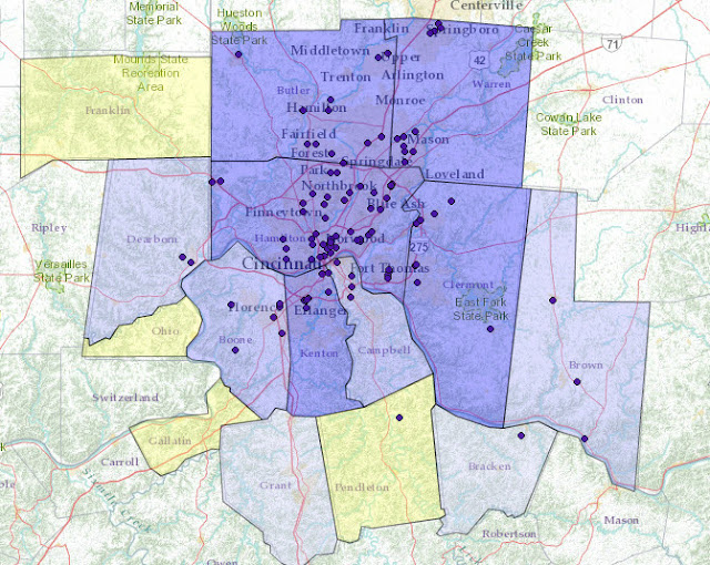
Map displaying number and location of pediatricians in the Greater Cincinnati, Ohio, region.
Thursday, September 27, 2012
Thursday, September 6, 2012
UDS Mapper: New Features and Updates
Map showing Health Center Program Grantee Dominance by ZCTA, 2011, for portions of Indiana, Ohio, and Kentucky.
UDS Mapper, a HRSA-funded project directed by the Robert Graham Center, helps inform users about the current geographic extent of U.S. federally (Section 330)-funded Health Center Program (HCP) grantees. It is one of many apps HealthLandscape has developed to visualize unique data sets.
Check out these new features and updates:
In the Explore Service Area box (formerly the Define Service Area box), there are three optional functions:
In the Map Elements box, we've added a fourth tab, Population Indicators. Use this new feature to visualize the following population-based data by ZCTA:
Data sources: American Community Survey (ACS) 2010 5-year and 3-year estimates; CDC Behavioral Risk Factors Surveillance Survey (BRFSS) 2010; CDC Vital Statistics 2009; CDC Area Resource File 2011
Use the indicator slider to adjust the rate. You will see the ZCTAs where the rate is greater than or equal to the number that you set on the slider.
Roll your mouse over a ZCTA and see a list of up to five HCP grantees with the share of total HCP patients each center sees.
UDS Mapper uses the most current data sets available, including the 2011 UDS data and the 2006-2010 ACS demographic estimates.
Take advantage of upcoming training opportunities to demonstrate UDS Mapper's new features:
Or, if you're planning to attend the National Association of Community Health Centers (NACHC) Community Health Institute (CHI) conference in Orlando:
Need more info? Click here to contact the UDS Mapper team.
UDS Mapper, a HRSA-funded project directed by the Robert Graham Center, helps inform users about the current geographic extent of U.S. federally (Section 330)-funded Health Center Program (HCP) grantees. It is one of many apps HealthLandscape has developed to visualize unique data sets.
Check out these new features and updates:
Individual Health Center Program Grantee Service Areas
In the Explore Service Area box (formerly the Define Service Area box), there are three optional functions:
- By Geography: View patient and demographic data by Zip Code Tabulation Area (ZCTA).
- New! By Patient Origin: Select individual HCP grantees and see their service areas according to patient-reported Zip Codes.
- New! By Distance: Determine the potential service area included within a driving time or distance to a given point.
Map showing ten-minute drive time around Wheeling, West Virginia.
New! Population Indicator Sliders
In the Map Elements box, we've added a fourth tab, Population Indicators. Use this new feature to visualize the following population-based data by ZCTA:
- % of population in poverty
- % of population low-income (less than 200% of poverty)
- % of population not employed
- Low birth weight rate
- Age-adjusted mortality rate (per 100,000)
- % of adults ever told have diabetes
- % of population uninsured
- % of adults with no dental visit in past year
- % of adults who have delayed or not sought care due to high cost
- % of adults with no usual source of care
Data sources: American Community Survey (ACS) 2010 5-year and 3-year estimates; CDC Behavioral Risk Factors Surveillance Survey (BRFSS) 2010; CDC Vital Statistics 2009; CDC Area Resource File 2011
Use the indicator slider to adjust the rate. You will see the ZCTAs where the rate is greater than or equal to the number that you set on the slider.
Enhanced Rollovers
Roll your mouse over a ZCTA and see a list of up to five HCP grantees with the share of total HCP patients each center sees.
Most Current Data
UDS Mapper uses the most current data sets available, including the 2011 UDS data and the 2006-2010 ACS demographic estimates.
*****
Take advantage of upcoming training opportunities to demonstrate UDS Mapper's new features:
- Webinar: September 19 (Click here to register. Content has been changed to focus on the new features of UDS Mapper.)
Or, if you're planning to attend the National Association of Community Health Centers (NACHC) Community Health Institute (CHI) conference in Orlando:
- One-on-one training sessions: September 9-11 (To sign up, click here.)
- What's New with the UDS Mapper: September 10
- Community-Oriented Primary Care (COPC) training session/learning lab: September 11
Need more info? Click here to contact the UDS Mapper team.
Labels:
Health Center Program,
Service Areas,
UDS Data,
UDS Mapper
Subscribe to:
Comments (Atom)


